Cloud formation can be seen in the earth’s homosphere. Nephology is the science of clouds. Clouds form by the condensation of water vapours into water droplets or ice crystals. Stratus, cirrus, stratocumulus, cumulus and cumulonimbus are common types of clouds in the troposphere, stratosphere and mesosphere.
Clouds in the stratosphere and mesosphere regions appear as sheets, wisps or ripples. Oppositely, clouds in the troposphere are responsible for the climatic changes on earth. Clouds are generally classified as high, mid and low-level clouds based on the distance from the ground surface.
This post mainly explains the definition, some fun facts about clouds and steps involved in cloud formation. You will get to learn the types of clouds based upon their appearance and the kind of weather they produce, along with the diagrams of each type.
Content: Cloud Formation
What are Clouds?
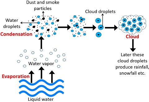
They are the visible masses of clumped water droplets or ice crystals in the atmosphere. Earth’s weather and climate are generally monitored by the type of cloud formed in the atmosphere. For the clouds to appear, the evaporation of water vapours is the preliminary step. Later, vapours condense into water droplets or ice crystals. Water molecules possess cohesion property through which they interact with the smoke and dust particles and ultimately form clouds.
Fun Facts
Clouds usually appear white, blue or grey, and may also appear brightly coloured. The appearance of white clouds is due to the uniform scattering of all the wavelengths of visible light by the molecules of water droplets or ice crystals, and the mechanism is called Mie scattering. Hence, clouds generally look white against the blue sky.
You may have also seen the grey or dark coloured clouds during the rainy reasons. Clouds appear grey when they become thicker or denser due to the accumulation of more water droplets or ice crystals. Such clouds completely block the sunlight and appear grey or dark coloured.
When direct sunlight is not striking the clouds, i.e. during the morning, they appear blue due to light reflection. Sometimes, haze and dust in the atmosphere are responsible for the yellow, orange and red colouration of clouds.
Cloud Formation Process
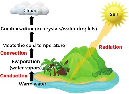
Formation of water vapours is necessary for the cloud formation. The amount of water vapours in the atmosphere is quite variable and depends upon the atmospheric temperature. Clouds form through evaporation, followed by the condensation of water vapours.
Evaporation
We know that evaporation is the phase transition of water from a liquid to the gaseous phase. Evaporation is very much similar to the vapours produced during the boiling of water.
Likewise, the sun’s radiations heat the water bodies like ponds, lakes, oceans etc., to produce water vapours. Eventually, the water vapours become suspended in the air, and they possess considerable freedom of movement or kinetic energy.
Thus, water molecules in the gaseous state have enough energy to escape due to their lower density than the air surrounding them. As a result, tiny particles or water vapours rise upwards into the air above the surface through evaporation.
The warmer the water is, the particles have more thermal energy and have high tendency to escape into the air. Likewise, the water can evaporate faster as the air with low relative humidity increases. Plants also release water vapours through tiny pores (stomata).
Guard cells regulate the opening and closing of the stomatal apertures to allow gaseous exchange between plant cells and surrounding through a process known as transpiration. Therefore, evaporation and transpiration are the two processes releasing water vapours into the atmosphere.
Condensation
After evaporation, the warm air parcel goes much higher in the sky and reaches a certain height where the temperature and atmospheric pressure drop. At this point, the warm air parcel becomes cool as the surrounding air cools below its dew point or point of saturation.
Now, the vapours enter the condensation nuclei and turn into liquid droplets or ice crystals. Later, tiny masses of liquid droplets or ice crystals form once they combine with the particles of smoke and dust. Later, these small masses transform into clouds as the visible masses of liquid droplets or ice crystals.
Types of Clouds
Clouds are colloids containing water droplets or ice crystals and wastes. They vary in shape and size. Clouds form at the ground surface are called fog or mist. Cirrus, stratus and cumulus are the three common types of clouds. Besides that, you can see some other forms of clouds in the troposphere. Depending upon the distance from the earth surface, clouds generally appear at high, mid and low altitudes.
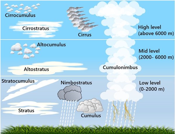
High-level Clouds
They appear at nearly 5-13 Km above the earth’s ground surface and include cirrus, cirrocumulus and cirrostratus clouds. High-level clouds primarily contain ice crystals.
- Cirrus: It is the most common form that appears as thin and wispy strands. It has a silky sheen appearance. Cirrus clouds lit up longer among other clouds. Such clouds generally appear white and light grey. They are also called mare’s tails because their shape resembles the tail of a horse. Cirrus clouds indicate a warm front on the way.
- Cirrocumulus: Such clouds have small white fluff patterns that extend miles and miles over the sky. Cirrocumulus clouds seem like greyish-coloured fish scales and are called mackerel sky. It exhibits features similar to cumulus and cirrus clouds. Cirrocumulus clouds indicate a fair, but cold weather. Here, one interesting feature to note is that it neither interacts with other clouds nor produces rainfall. Cirrocumulus clouds reflect yellow and red colour before sunrise and after sunset.
- Cirrostratus: It has a thin sheet-like appearance and may appear grey or white. Such clouds are quite translucent and composed of ice crystals. The thickness of cirrostratus clouds varies, and they turn into altostratus clouds after descending to a lower altitude. Cirrostratus clouds generally move in a westerly direction. The formation of such clouds indicates that the rainfall or snowstorm may occur in the next 12 to 24 hours.
Mid-level Clouds
They appear at nearly 2-7 Km above the earth’s ground surface and include altocumulus, altostratus and nimbostratus clouds. Mid-level clouds may contain a combination of water droplets and ice crystals.
- Altocumulus: Such clouds grow by convection and look like parallel bands or spherical masses. They appear white to grey with shaded edges. Altocumulus clouds produce light to moderate rainfall.
- Altostratus: Such clouds appear evenly grey and smooth. The appearance of altostratus clouds indicates that a storm with persistent rain or snow might come. Sometimes, altostratus clouds are called boring clouds because they are featureless with uniform grey or blue-grey coloured clouds over the sky. They appear ahead of the warm frontal system. Altostratus clouds become nimbostratus once the rain hits the ground.
- Nimbostratus: These clouds are the heavy rain bearers producing persistent rain. They appear dense and dark coloured. Nimbostratus clouds are thick enough to block out the sun entirely. Nimbostratus clouds descend to lower altitudes and form by the condensation of water vapours into water droplets.
Low-level Clouds
They appear at nearly 0-2 Km above the earth’s ground surface and include stratus, cumulus, cumulonimbus and stratocumulus clouds. Low-level clouds are made of water droplets.
- Stratus: Such clouds appear as thin horizontal layers, which cover large areas in the sky. They are the lowest-lying cloud type and have a fog-like appearance. Their thickness varies. The stratus cloud produces benign rainfall and frequently appears in the coastal and mountainous regions.
- Cumulus: Such clouds are the most attractive resembling a cauliflower shape. They appear as a pile of cotton with white tufts on the top and a dark base. The appearance of cumulus clouds indicates a sign of fair weather. They may discharge light showers.
- Cumulonimbus: Such clouds appear white and fluffy. They develop vertically from low to high altitudes and are also called towering clouds. At low levels, they are made of water droplets. Conversely, they are made of ice crystals at high altitudes. It produces rain, thunderstorm and lightning .
- Stratocumulus: Such clouds resemble a thick white blanket and are more or less similar to cumulus clouds. They can also join together. Such clouds have a flattened base and ragged upper part. Stratocumulus clouds possess light to dark grey hues, and also responsible for the light drizzles.
Significance
Cloud formation plays a significant role in the water or hydrological cycle, as precipitation of clouds produces rainfall that brings water back into the ground. In addition, clouds play a key role in weather forecasting.